;)
London Trolleybus on Route 654 at the "Robin Hood"
|
|
| Click on picture [38] for an enlarged version |
Comment by David Bradley:
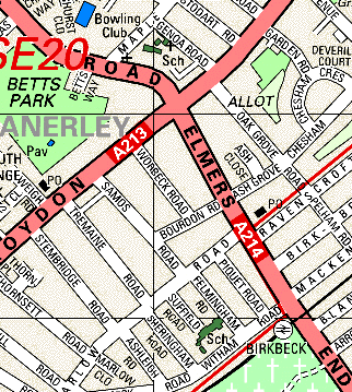
At the "Robin Hood" junction, the trolleybus is about to make a left turn into Anerley Road from the A213 Croydon Road. A right turn would be into the A214 Elmers End Road where Birkbeck Station, served by Croydon Tramway, is just over a quarter of a mile away.
From: "Glyn Matthews" <glyn@bbpg.swinternet.co.uk>
I used to take the 654 to Anerley Primary and Junior School in Anerley Road. The school was situated behind Anerley Town Hall adjacent to Anerley Station. On one in three journeys we had to wait for the conductor to put the boom back at the 'Robin Hood' turn, those were the days!
From: "Chris Cook" <C.Cook@btinternet.com>
 |
|
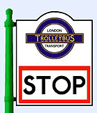
The unique trolleybus stop sign to be found just around the corner in Anerley Road |
On the ground at the base of the traffic light - a flare can for use in fog. Can you imagine leaving
such a thing unguarded in a public street today and expecting it to stay there?
The area behind the bus, on the street corner, is a vacant site. The Holy Trinity Church that formerly stood there was, I
think, destroyed in WW2. You can still see its vacant notice board in the picture. A new church/church hall was eventually
put up in its place in the early 60's. The corner sported posters for 30 years of the 'witty Christian' type, changed every
fortnight - '7 days without prayer make one weak', that sort of thing. I don't know who thinks them up but I
passed there every day for six years and I don't recall any repeats.
Then in 1995 the new buildings were themselves demolished and the site re-used again, for some houses built for a Housing
Association. In October 1999 there is still a notice board in the same place as it was in 1959 [behind the studenty-looking bloke].
So the notice board position has survived three sets of buildings on that corner!
From: "Charles Nightingale" <charles.nightingale@btinternet.com>
Holy Trinity Church still stood many years after the war, having suffered bomb-damage - [nose-cone of
the steeple knocked off leaving a strange little flat top]. We used to stand waiting for a bus back home, after having
attended a service by the rival establishment in Genoa Road, the next one after the turn the trolley is about to
execute.
Marvellous site - bad for me, I am, my wife tells me, too easily afflicted by nostalgia! It is about fifty years since
I lived there, but the Crystal Palace area still holds a fascination form me - even though our house was damaged by a
bomb, and V1s and V2s fell all round!
Keep this site going, it's just too good to be true!
;) |
| Click on picture [JK11] for an enlarged version |
Another comment by David Bradley:
The 'Robin Hood' cross roads in the 1920s must have been quite a Mecca for tram enthusiasts observing cars on route 4 to Thicket Road [Penge] and route 5 to Crystal Palace. Nearby, in Oak Grove Road was SMET's Penge Depot [the buildings could still be seen in the early 1980s], which was approached down the rather steep gradient from Croydon Road and could house 15 tram cars.
![]() Another depot picture [JK12]
Another depot picture [JK12]
Peter Gibbon's Tramlink map is from:
![]()
 |
|