;)
;)
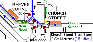
Reeves Corner end of Tamworth Road
|
|
| Click on picture [418] for an enlarged version |
|
|
| Click on picture [1010] for an enlarged version |
Notes by David Bradley
Picture 418 is a view of the Reeves Corner end of Tamworth Road and shows that the end was well and
truly nigh for trolleybuses on Route 630, when this picture was taken Route 654 had already gone but this is where the
two routes diverged. Even with the disappearance of the overhead wiring junction, the traction support pole is left with
the scars of where the point indicator box used to reside.
Subsequently, not only were the trolleybuses to disappear but also many of the buildings in Tamworth Road, although the
Eagle Public House remains, much as it was then, to this day. This end of Tamworth Road used to be a comprehensive
shopping area in 1959 but few shoppers are found in this location now. Parking of private cars has been banished to nearby
multi-storey car parks, where you don't get much change out of £1.50 for a two hour stay, with just a few tram
passengers alighting to visit the remaining retail shops. The job lot of street furniture does little to enhance
the environment in down town Croydon.
Picture 1010 captures the atmosphere some forty years later just to record the merging
of the tram routes from Wimbledon to the left and services via East Croydon Station to the right.
|
Peter Gibbon's tramway diagram is from: |
 |
This part of Croydon is known, and shown on many maps, as
Reeves Corner, since there is a large furniture store of that name in the locality. The buildings were originally owned
by SMET, but sold in December 1946 to W. Reeves. Earlier maps consider this to be the Pitlake area of West Croydon.
SMET's tram track was interesting at the bottom of Tamworth
Road as the joining single track in Lower Church Street [lost under Roman Way] swung into Tamworth Road's double track
as a wrong way working for trams bound towards West Croydon. A crossover, located where Tramlink's merging tracks now
are, quickly restored normal practice. The single line section was controlled by light signals.
Roman Way replaced the old Pitlake Bridge. It would be nice to have a map of the area as it was in 1959 - if you can
help in this matter please
me in the first instance.
From: "Graham Boseley" <graham.boseley@iclway.co.uk>
Thanks for putting up this website on the trolleybuses. I was born in South
Croydon in 1939 and lived in Waddon until 1963 when I moved away from home.
My memories include trying to keep up with a trolleybus across Mitcham
Common on my cycle [unsuccessful] and watching the trolleybuses changing
lines at the bus stop at the bottom of Tamworth Road. I saw a number of arms
come off the wires at different times.
From: "Brian Mullally" <briant@eagle.ca>
Discovered your wonderful site. Brought back a lot of old memories. I remember viewing one of the 'new' trolleybuses outside the Croydon Parish Church, would have been in the mid 30's. While my friend and I attended John Ruskin he used the pole outside the Eagle to switch the "points" and after the trolley bus left the stop and made it's turn toward Pitlake Bridge. It came off the line. Big Sparks we ran thru the Eagle and out the back in order to escape the inspector.