 |
 |
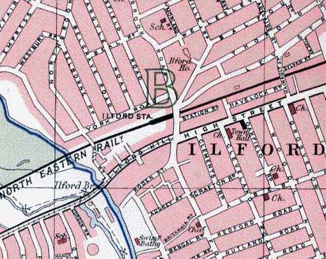
| 1938/39 Map [Note the tramway from the west terminating at Ilford] | 2004 Map |
Ilford Town centre
|
|
| 1938/39 Map [Note the tramway from the west terminating at Ilford] | 2004 Map |
;) |
| Click on picture [RH12] for an enlarged version |
;) |
| Click on picture [RH13] for an enlarged version |
From: "Cllr Hickey" <Morris.Hickey@redbridge.gov.uk>
The precise location of the two trolleybus pictures shown here is just to the left of the
letter 'I' in 'Ilford' on the pre war map. The photographer is riding on a trolleybus during 1958 that has just passed
through Ilford Hill/High Street [which is in fact High Road, not High Street; nobody locally can ever remember 'High Road'
being called 'High Street'. Even map makers do not always get it right! 'High Street' is in Barkingside, some 2-3
miles away]. and going towards Roden Street.
The routings from Barking were along Ilford Lane as far as Roden Street. Route 691 then proceeded due north to Ley
Street where it turned left towards the depot, Newbury Park and Barkingside. Route 693 turned right into the High Road
towards Chadwell Heath. Short workings from Barkingside to Ilford Broadway [a location rather than a street name] would
come up from Ley Street, turn right into Myrtle Road [the unnamed one on the map linking Ley Street and Thorold Road]
to a stand in Thorold Road before leaving via Balfour Road and turning though about 180 degrees into Ley Street.
Route 663 from Aldgate would arrive at Ilford Hill, turn left into Station Approach [the unnamed section between
Ilford Hill and the junction of Cranbrook Road with Balfour Road/Ley Street] then into Ley Street, Myrtle Road,
Thorold Road, Balfour Road back to Station Approach and Ilford Hill.
From August 1958, with the withdrawal of the weekdays only 695 from Bow Church to Chadwell Heath, route 663 was
extended on weekdays from Ilford Hill through High Road to Chadwell Heath using the Ilford terminus on short workings
and Sundays.
From about summer 1959, when Balfour Road was 'stopped up' at its junction with Ley Street/Station Approach,
in order to facilitate the widening of Station Approach and the entry to Ilford Lane, a new link between Balfour
Road and Ley Street was built, to the west of Myrtle Road. Station Approach became one way northbound, Hainault
Street one way southbound, and overhead wires were put up in Hainault Street linking Ley Street with High Road.
Barkingside to Barking journeys in route 691 were then routed from Ley Street through Hainault Street turning right
into High Road and left into Ilford Lane. Short workings continue to use Ley Street, Myrtle Road, Thorold Road,
Balfour Road and the new link to return to Ley Street and Barkingside. Route 663 leaving the Ilford terminus did
so by way of the new link, Ley Street, Hainault Street and High Road back to Aldgate.
From: "John Prentice" <john.prentice@www.tramwayinfo.com>
The track on Ilford Hill from Ilford Bridge to Ilford Broadway as shown on the 1938/9 map was built
by Ilford Council in 1903. The track from Ilford Bridge to Manor Park [off to the left of the map] was built by East
Ham Corporation. The through service was not operated by Ilford at all, but was jointly run by East Ham, West Ham and
the LCC. It passed to London Transport in 1933. The actual service run was number 63, Aldgate to Ilford Broadway.
The last tram ran on 5th November 1939.
The correct dating of your map is 1938/9 as it does not show the Ilford local routes which had closed on 6th Feb. 1938
just leaving the through trunk service.
On the The Tramway Information Web Site there is a
postcard for Ilford which gives a
potted history of the local system and shows an East Ham car on the track in question. The trams on Ilford Hill
were replaced by the
663 trolleybus route which was occasionally extended along the High Road over
what was one of the Ilford local tram routes to terminate at Chadwell Heath. It ran until 18th August 1959
when it was replaced by RT buses.
From: "WARREN HANLON" <warren.hanlon@btopenworld.com>
My grand-aunt and my great-grandmother
lived in Audrey Road, the next road up [towards Barking] from Roden Street. As correctly mentioned in the caption,
the public conveniences were at the junction of Roden Street and Ilford Lane. When I was a child, my mother, sister and
I used to visit my aunt several times a week, even into my early years at grammar school. My aunt died in 1973 [by
which time I was aged 30], so I would have been familiar with the area up until that time. I must have walked this
stretch many hundreds of times!
The siting of the bombed-out Hippodrome was not where stated in the caption. The Hippodrome ruins, which were in
evidence for a number of years, were actually situated at the corner of Balfour Road and Ley Street, close to
Ilford station, but diagonally opposite to same. Eventually the Hippodrome ruins were cleared and a branch of
"C & A" built there. Opposite Ilford station was a department store, named "Bodgers". I moved
from Ilford in 1973, so beyond that date I have little knowledge of the area.
The caption statement "The photographer has his back to High Road and Station Approach [now part of Cranbrook
Road]" is correct. Towards the corner of Ilford Lane / High Street, there was a pub, behind the photographer's
position. I remember well the smell as - when a child - I walked past it. Just a little way down, on the right, from
the trolleybus moving away [towards Barking] from the photographer I remember a butcher named Bush, and a small cafe.
A little further along on the right there was the Ilford Film factory, which backed onto my aunt's garden.
From: "Cllr Hickey" <Morris.Hickey@redbridge.gov.uk>
Warren Hanlon is wrong with his comments about the location of Ilford Hippodrome. The Hippodrome was a theatre in Ilford Lane. The bombed premises at the junction of Balfour Road and Ley Street was a cinema. The replacement building first housed a branch of C&A, and is now the Woolworth store.
From: "WARREN HANLON" <warren.hanlon@btopenworld.com>
Morris Hickey is absolutely correct when he says that it was a cinema which stood at the location
I mentioned, and not indeed the Hippodrome. It came back to me later, and in fact I was going to post an update
myself once I realised my mistake a few hours after typing it.
I would wish to say that my comments re Roden Street, Ilford Lane, etc., were meant in a spirit of helpfulness and
in the hope of adding something to this excellent website.
From: "Kimberly Adams" <dogberry3@yahoo.com>
Just wanted to add a quick note to your site. While I know nothing about the old trolleybuses I do currently live in Ilford and wanted to say that Bodgers does still exist. I don't know where it was before, but now it is almost directly across from the station. Just look to your right as you exit the station and you'll see it. So now it is located on Cranbrook road but in the town center area. I don't think you can enter it through the exchange mall but it is very close to it. Hope that satisfies the curiosity's of those wondering about Bodgers. They have a website as well. www.bodgers-ilford.co.uk
From: "Nick H (UK)" <nick@mridangam.com>
In picture RH12, just to the right of the trolleybus is a hanging shop sign 'Books'; that connects
in my brain to the old bookshop that, until recently, was on the corner of Ilford Hill and Cranbrook Road, which would
make the block with Jason's Wonder Stores on the corner the present Sainsbury's.
It would be Pioneer Market on the left, where it looks as if there is some sort of open-air market in the picture.
Pioneer market may be still standing, by the way, but not for long :-(
Nick writes a few days later from his earlier contribution:
Having looked at the maps on the site, I realize that I mean *Roden Street* and Cranbrook Road.
That section of road is now which is now Chapel Road.
After visiting the nearby Sainsbury's today now confirms my earlier observations. The details of the window frames,
the small break in the buildings before the two-storey building of which the bookshop is part and the architectural
detail on the top of that building all are correct. I'll try to take the camera and get a present-day picture sometime
soon :-)
It is a shame that the bookshop closed down, and a bigger shame that its shop front has been removed: it was very
attractive. Should have been listed :-( Anyone got a photo?
From: "Hugh Taylor" <isleworthdepot@trolleybus.net>
 |
This is a photograph of 1722 in Balfour Approach, Ilford; the photograph was taken between March
1958 and January 1959. Trying to establish the exact wiring layout in this road. Before this date, trolleybuses on
routes 663 and 691 left the stand in Thorold Road and travelled direct to the Broadway.
Due to a new road scheme at Ilford, from March 1958, trolleybuses on the revised layout turned immediately left from
Thorold Road to gain Ley Street.
The photograph only shows some of the wiring in Balfour Approach, and what I need to ascertain is the wiring layout
at the junction of Thorold Road with Balfour Approach where two sets of wires became one; 1722 has just passed over
that junction.
From: "Cllr Hickey" <Morris.Hickey@redbridge.gov.uk>
With reference to the 'two sets of wires becoming one'. This would only have applied during the period
when all departing vehicles turned left into Ley Street from Balfour Approach.
The Balfour Road wiring was really two parallel one-way sets. Short workings on 691 entered
Myrtle Road turning right off Ley Street westbound. 663s, and short working 693s, did so from Ley Street eastbound
turning left into Myrtle Road. The 691s travelled on the outer wires, the others on the inner ones, to a point in
Balfour Road where the 691 stand was ahead of the 663 stand, and the wires crossed over to allow departing 663s to
pass the waiting 691s.
They stayed this way in Balfour Approach with the departing 691s turning right into Ley Street and the departing 663s
turning right until 1959 when all departing vehicles turned left into Ley Street either to continue to Newbury Park
and Barkingside [691s] or to turn right into Hainault Street and then either right into High Road [663s to Aldgate or
691s/occasional 793 short workings to Barking] or 693s turning left [short workings going returning to Chadwell Heath].
I see that the vehicle is 1722, an SA1 class, and unique in that it is the only vehicle with a GGW index; the remainder
all had GLB registrations.
From: "Geoffrey Gillon" <geoffrey.r.gillon@talk21.com>
I certainly remember the Bandbox shop on the first picture! I only vaguely remember the
underground public conveniences at the end of Roden Street. The Hippodrome - or the bombed out ruins were on the left
foreground in my childhood - there was a bus stop there and I remember waiting there with my mum many times and peering
down through the window areas to see if I could see any dead bodies!
Opposite there was a shoe menders. To the left of that shop was a coffee bar in the fifties and also a book stall.
In fact you can see the 'books' sign. I will pass this on to my cousin Bernard as he may be able to shed some light;
I do believe the identification is entirely correct. I have a "brother and sister" contact in Australia and
they will enjoy these pictures as they lived just off Ilford Lane.
From: "Dennis Carl" <winky1@ozemail.com.au>
Obviously the top end of Ilford Lane, The second photograph [rear of bus] shows Daves Cafe, [yellowy fronted building] which was almost directly opposite the Pioneer Markets, which are around the bend on the left hand side.
;) |
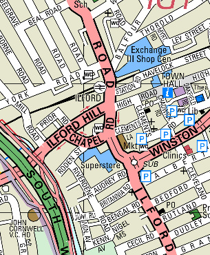
| Click on image to see complete map |
From: "Chris Veasey" <veaseys@nildram.co.uk>
An extract from Geographia Atlas which I reckon is spot on for early 60s, despite Geographia's
infuriating habit of not dating their publications. Bus roads in yellow. Shows Balfour Road cut off and new link to Ley St
mentioned by Cllr Hickey, but street network otherwise apparently unaltered. This atlas shows 'High Road' not Street.
An earlier Geographia atlas, evidently from early 1930s if not earlier [shows Crystal Palace and White City exhibition
complex] also shows 'High Road' so Bartholomew evidently got it wrong or well out of date in 1938/39 and Cllr Hickey is
right.
And finally [from me - I've now run put of atlases you'll all be pleased to learn], just to flog a topic to death the
1963 edition of the Bartholomew atlas shows [in addition to the correct High Road name] the new Balfour Street link
named Balfour Approach [barely legible on map but included in index], but fails to show Balfour Street stopped up at
west end.
![]() View this 1963 map.
View this 1963 map.
From: "Patrick G Linsley" <cyberbia@ntlworld.com>
I saw Cllr Hickey's comments about LT Trollybuses and I was wondering if help could be given
to locate the spot that the British Gaumont cinema stood in Ilford.
The reason why I'm asking is that my mum used to work in this cinema in Ilford sometime during the war years - she was
born in Chester Rd, Seven Kings - and I'm trying to locate the spot so that sometime this year I can visit Ilford and
take a photo of the place.
I've been told that it stood at the former junction of Ley Street, Balfour Road and Cranbrook Road at a point
roughly opposite Ilford Station. However, I've now seen here that the Ilford Hippodrome stood on that site.
From: "Cllr Hickey" <Morris.Hickey@redbridge.gov.uk>
The Gaumont site is indeed opposite Ilford Station, now occupied by a Woolworth store. The comment about the 'Hippodrome' is not correct. It was in Ilford Lane, on a site in what is now Chapel Road but before a road widening scheme took place in about 1959/60.
From: "Lawrence Murphy" <lawrencemurphy@tiscali.co.uk>
The name of the bookshop whose exterior sign is visible in Roden Street, was Terry's Bookshop. It was piled high to the ceiling with shelves full of what always seemed to be enormous volumes. There were also always piles of secondhand comics on the floor - Beano and Dandy especially.
;)