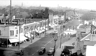
Pictures from the Frith Collection of Thornton Heath
If you have trawled through the rest of this site you would have probably guessed correctly that my early years
were spent in Thornton Heath, close to the Clock Tower - a destination blind entry for bus route 159 until it was replace
by route 250 in the 1990s. And until April 1951, tram route 42 went past the end of road every few minutes.
Like many other users of the Internet age, I entered into my favourite Search Engine my road name and again the generic
place name Thornton Heath. Not much of a result for Stuart Road, but a search on Thornton Heath threw up 183,000 results of
which one referred to some
prints for sale from the Firth collection of historical pictures of the area. Thumbnail
copies of each picture appeared but the caption date for each was shown incorrectly. My opinion of what the date for
each picture was forwarded onto the publishers and their response is shown below. It is pleasing to note that their
index now contains this revised information.
Subsequently further information for some of the pictures has come to light and this new data is now shown. If any visitor
to this site wishes to add their own comments, this would be most welcomed - my email address is shown at the foot
of this page.
-----Original Message-----
From: Tina Leary [mailto:tina@francisfrith.co.uk]
Date: Tuesday, January 6, 2004
Subject: Thornton Heath
I would be most grateful for some guidance re the incorrect dates. Naturally we need to keep our database as accurate
as we can so if you would advise corrections or some info to help with corrections it would be appreciated.
![]()
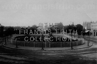 |
| Thornton Heath. The Pond 1894, Surrey. Ref: 34372 |
I don't think this place has ever been known as just "The Pond"; it always seems to have been known as
Thornton Heath Pond. Only in recent times has Thornton Heath became part of Surrey, in c1894 the locality
was in Surrey.
I would date the picture as being 1898.
Further historical notes:
Originally a large, open pond it gave the area its name. In the 18th century it was an important watering place for
cattle and horses along the busy London to Brighton Road.
In 1897 railings were put up around the edge of the pond to put a stop to numerous traffic accidents. This included
the Brighton mail coach ploughing straight into the water in heavy fog in 1891. At the same time, an ornamental
fountain was placed in the centre of the pond to mark Queen Victoria's diamond jubilee, replacing the original
fountain.
The area is also known as the location of gallows during the 18th century where numerous convicted highwaymen were
hanged for their crimes but for many of the borough's older residents, the area holds less dramatic, happier memories
as a place where they would gather to paddle and fish as youngsters.
In 1953 the pond was filled in and turned into an ornamental garden with a small pool. But due to sporadic incidents
of vandalism, the decision was eventually made in 1975 to fill in the pool as well and it remained so until 2003 when
a new water feature was built through funds from Croydon Council's Smarter Croydon initiative.
![]()
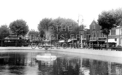 |
| Thornton Heath Pond c1955, Surrey. Ref: T262023 |
Do I detect the fountain as actually working? My recollections of the 1950s are at that time the fountain had not worked
for some time so we are back to the period between 1945 and 1948. It is difficult to tell but there are clues there that
indicate that trams are still running.
Early photographs were occasionally hand coloured and I found one of a
Croydon tramcar passing the Pond sometime between 1905 and 1910. The
picture shows that the railings erected some 10 years previously were long gone.
![]()
 |
| Thornton Heath, c1955, Surrey. Ref: T262045 |
Should be perhaps dated 1953 or 1954, as it looks as though it was taken shortly after the pond had been filled in.
![]()
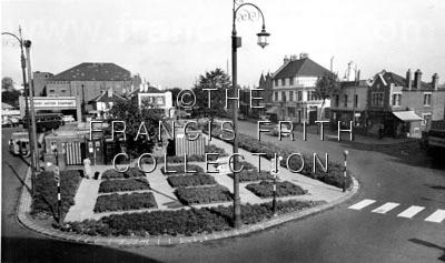
 |
| Thornton Heath, London Road c1960, Surrey. Ref: T262041 |
It could be 1960 but I think that the street lighting had been modernised by then although The Pond area as a roundabout
came into existence about 1957; perhaps the picture is best dated 1958.
Elsewhere on this site are two pictures taken in the same area; one of a
'Feltham' waiting at the traffic lights at the same location as the
adjacent picture, and the other of a
42 tram emerging from Brigstock Road into London Road. [Brigstock Road runs
up the side of Barclay's Bank seen on the right hand side of this picture]. The pictures from my postcard collection were
probably taken in 1950.
![]()
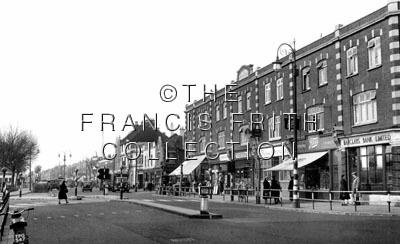
 |
| Thornton Heath, Brigstock Road c1955, Surrey. Ref: T262002 |
Tram Services ceased in early 1951 and certainly all traces of the system were gone by 1952. The picture could be of 1937
but weren't the original Belisha Beacons just on black poles? The car bumper and the cyclist mudguards appear to be
painted "wartime" white so I would tend to go for the 1948 period. Again we are in Surrey!
Picture probably taken from the top deck of the tram.
![]()
 |
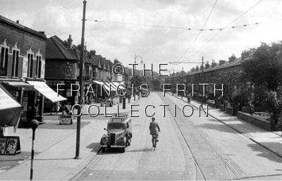
| Thornton Heath, High Street c1950, Surrey. Ref: T262007 |
Taken at the top end of Thornton Heath High Street, it is Nursery Road to the left and Grange Road to the right.
The cyclist and car are leaving/joining Whitehorse Lane.
The flower bed in the picture did not form a roundabout with the High Street. The building on the corner of Grange Road
and the High Street is a public house.
The car in foreground looks like a Morris Minor, which was introduced in 1948, and the summer-attired lady cyclist
implies the picture was taken 1950 or earlier Since trams were withdrawn in April 1951. The dating of the picture is
therefore between mid 1948 and mid 1950; with the evidence of the other pictures on this page perhaps more likely 1948.
![]()
 |
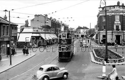
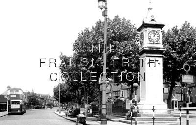
| Thornton Heath, Clock Tower and Brigstock Road c1960, Surrey. Ref: T262013 |
Interesting picture this one because I lived in nearby Stuart Road from 1939 to 1964 and one thing is absolutely certain is
that it was not taken 1n 1960! Because of the presence of the tramway infrastructure, it is pre 1951.
What does catch my eye is the railway telegraph pole in the distance and the style and positioning of the keep list islands.
I would date this picture between 1942 and 1948 although further research on John Toby's shop might indicate a period
between 1946 and 1948.
Stand on the steps of the Clock Tower on the 12 June 1949 and face the camera man to capture this
picture of two trams in Thornton Heath High Street.
![]()
 |
| Thornton Heath Station Approach, c1950, Surrey. Ref: T262004 |
1948.
Street.
![]()
 |
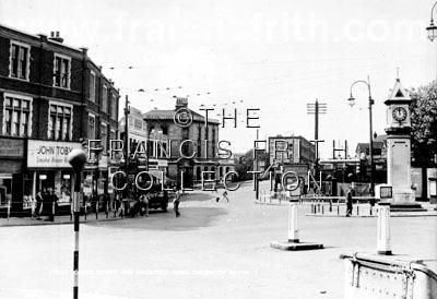
| Thornton Heath, Clock Tower and Parchmore Road c1955, Surrey. Ref: T262017 |
Clearly taken on the same day as picture T262013 and therefore reinforces the date as immediately post war by the style
of the bus; I am tending to favour 1948 but only a enlargement of the picture would help further particularly if the
contents of the poster behind the two gents sitting on the Clock Tower steps can be read.
This was the terminus of route 159 and the STL on layover appears to have its rear route number and destination panels
painted over; introduced as a wartime measure, persisting for some years afterwards. There are no other wartime
indications and with "John Toby" shop front sign in T262013 looks quite modern, so probably post-1945 - perhaps
on the same day as T2624007.
My picture of this location was taken one Sunday afternoon in 1960.
![]()
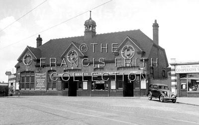 |
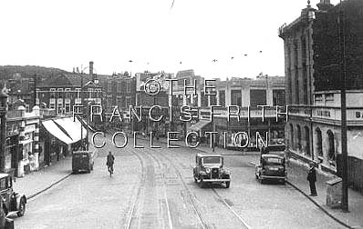
| Thornton Heath Station c1955, Surrey. Ref: T262018 |
For all the reasons previously given, I would date the picture as being 1948. Probably taken on the same day as the
previous two pictures.
A postcard I have in my collection of Thornton Heath Station also has the date
wrong, claiming it was taken in 1940. In fact if you look closely at the picture you will see their are no tram tracks
and that a replacement bus stop for tram route 42 is just outside the station entrance, so the picture has to be post 1951.
With other minor clues present in the picture it was probably taken in 1953.
![]()
 |
| Thornton Heath, London Road c1955, Surrey. Ref: T262042 |
I was having great difficulty in knowing where this is. At first it was thought to be at the bottom of Brigstock Road,
however, Mike Mellor [now in Wellington, NZ] states that the picture shows the Colliers Water Lane/London Rd junction;
the clue is the double-gabled 3-storey brick building in the middle with a white 2-storey building to its right.
This pair appear in all the Thornton Heath Pond pictures.
It looks as if it's just after the pond became a roundabout, which in an earlier comment you say was c1957, rather than
c1955. Being a South Croydonian, I don't recall such details about the far-flung northern reaches!
![]()
;)
;)
;)
;)
;)
;)